


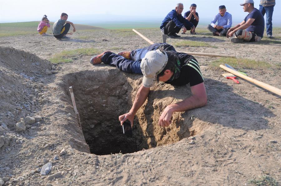
Krzysztof Gaidzik, PhD during the creation of a high-resolution digital model of the excavation walls | Photo by Christoph Grützner
| Małgorzata Kłoskowicz |
In November 2023, an earthquake with a magnitude of 4.6 occurred in Uzbekistan. Although this event did not cause major damage, many residents still remember the effects of the 1966 tremors, which led to the death of many people. Due to the geotectonic location, violent phenomena of this type are not uncommon in Uzbekistan. The memory of past earthquakes may have been preserved both in the geological record and in the buildings there. An international team of scientists, joined by Krzysztof Gaidzik, PhD from the Faculty of Natural Sciences of the University of Silesia, is looking for such traces in Uzbekistan. The research results will allow to estimate the seismic risk in the studied area and, as a result, take actions to protect the most valuable monuments against the effects of subsequent earthquakes.
“You can start tracking traces of historical earthquakes by looking at holiday photos posted on the Internet. Before we go on a research expedition, we look for any irregularities, deviations, fragments that have been repaired, or architectural elements that do not fit into the whole. This is a good start in the case of archaeoseismology, which I deal with”, says Krzysztof Gaidzik, PhD, geologist from the University of Silesia.
Although he is most interested in tectonic research in the active subduction zone of Peru and Mexico, last year the scientist completed a project on castles and churches in Lower Silesia, the Beskids and the Świętokrzyskie Mountains, where he examined traces of historical earthquakes. As he admits, he also dreamed of a trip to Asia. The dream became reality thanks to one of the scientific conferences, during which he met Prof. Richard Walker from the University of Oxford. The British scientist has been conducting paleoseismological research in Central Asia for several decades and has recently started a research project in Uzbekistan. After listening to Krzysztof Gaidzik’s lecture, Prof. Walker offered him participation in the next expedition. The Polish scientist joined the team that already included: Christoph Grützner, PhD from the Friedrich Schiller University in Jena, as well as Prof. Makhir Usmanov Turabovn, Tahir Zahidov Kamilovich, PhD and Zukhriddin Shukurov Fazliddinovich, PhD from the Institute of Seismology of the Uzbek Academy of Sciences.
“I knew that this was an area prone to strong earthquakes, so I could assume that their traces had been preserved in the architecture. I started looking through photos on the Internet and noticed more and more structures that interested me. In such a case, we are never sure whether it is a matter of taking the photo, the photographer’s hand or perspective; however, I had the reason to go into the field and see the architectural pearls of Uzbekistan with my own eyes”, says the Polish researcher. The trip lasted almost two weeks and was of an exploratory nature. Participants were interested in topics related to both paleo- and archaeoseismology.
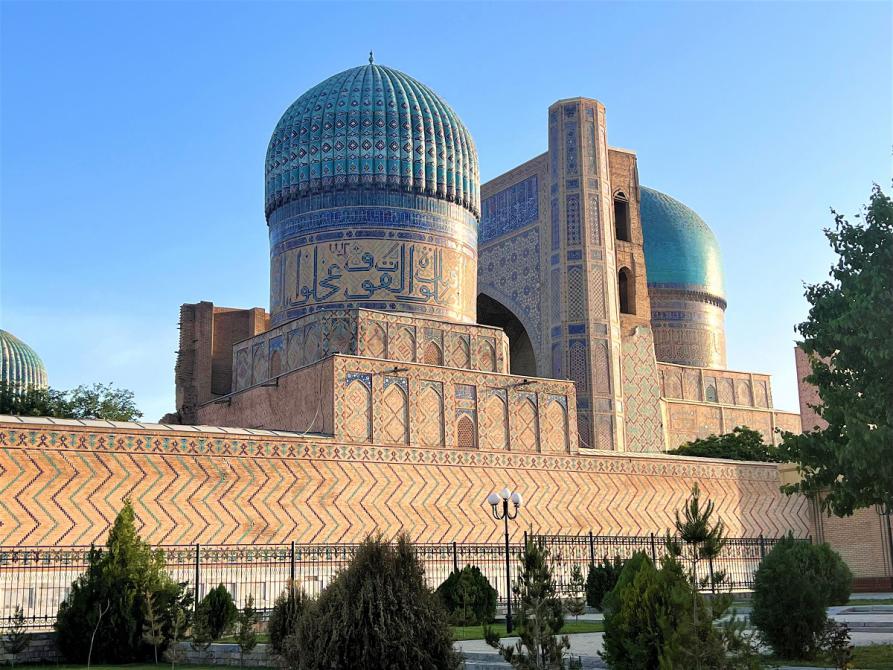
The Bibi-Khanym mosque towering over Samarkand | Photo by Krzysztof Gaidzik, PhD
The difference between these two scientific disciplines is significant, although both complement each other. As the scientist explains, they differ in terms of time scope and research subjects. In the case of paleoseismology, the geological record is analysed to find traces of Quaternary earthquakes, whereas archaeoseismology recognises ancient seismic events, the traces of which can be found in buildings and archaeological objects. In this case, researchers are looking for anomalies that are not the result of human activity or natural degradation processes related to time.
Preparations for the expedition also included conversations with archaeologists conducting research on site. The geologist was interested in all the structures that they couldn’t explain very well and that looked unusual. It could have been the result of erosion, an earthquake or human activity, e.g. as a result of warfare. To find this out, it is important to read reports and archaeological works. On this basis, specific locations that must be seen during the trip are selected. There, researchers look for deformations and deviations, and then interpretations begin to assess whether the observed phenomena may be related to an earthquake.
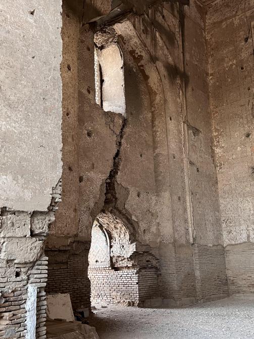
“After analysing the data, we decided to explore Kafir-kala (Kāfer Qal’a) located near Samarkand, a wonderful city which is part of the UNESCO World Heritage List. Kafir-kala is an archaeological site probably inhabited since the 4th century AD, according to sources, destroyed in 712 as a result of the Islamic invasion, and then inhabited again by Muslims. We found there, both on site and in reports, deformations that were very interesting from my point of view. Not all of them could be explained as the effects of war”, explains the scientist. As an example, he gives a building with a semicircular arched ceiling.
“If we have a situation in which the ceiling fell completely and another room was built on it, then such a trace arouses my interest. I ask myself: why would an invading army destroy a building in such a way? This would be difficult to do and completely unprofitable. These are only indications, but many such elements together can indicate a connection to an earthquake”, says the geologist.
In addition to Kafir-kali, researchers also focused on selected objects in Samarkand, the Bibi-Khanym mausoleum and mosque, and the Registan architectural complex, i.e. the main square with three madrasas, in which each tower is tilted in a different way.
“We take into account the material from which the objects are built, but also the base surface. With this data, we went to France, where we met with architects and construction engineers to conduct tests. We used the so-called shaking table, a platform on which you can recreate the behaviour of a building in response to vibrations caused by an earthquake. We plan to build a model from the same material from which the objects in Samarkand were made, and then recreate the vibration conditions with known parameters to observe the emerging deformations”, explains the scientist.
In addition to traces of deformation, the geologist also looks for attempts to repair them, and these can already be dated. Unless, of course, the earthquake was so strong that it destroyed the entire city. Then you look for notes in various documents, e.g. travellers’ journals.
In the case of Samarkand, especially from the 15th century, additional sources appear due to the important trade route that passed through there. The preserved documents are being examined by archaeologists from the University of Oxford. The scientist from the University of Silesia also mentions legends that may contain an element of truth.
“There is a story about Ulugh-Beg, the brilliant grandson of the famous Timur. Well, Ulugh-Beg, while examining the stars, predicted the day of his grandfather’s death. So that day he rushed to Ishratkhana mausoleum to warn him. By shouting or by force (depending on the version of the story), he forced his grandfather to leave the building, and at that moment the earth shook and the vault collapsed, exactly in the place where Timur had just been sitting. So we have a lot of interesting details, we know where and what to look for in the structures of the historic mausoleum”.
The later, the more interesting data. Krzysztof Gaidzik, PhD mentions subsequent very strong earthquakes at the turn of the 19th and 20th centuries, when the greatest mausoleums of Samarkand were damaged. Cracks appeared in the walls, arches collapsed, and mosaics fell off. In this case, photos from before and after the disaster have been preserved.
“That is why we are in contact with scientists from the Uzbek Academy of Sciences, archaeologists and construction engineers. It turns out that sometimes simple architectural solutions would be enough to better protect the most important monuments against the effects of earthquakes. Of course, everything depends on the strength of such an earthquake. Moreover, the results of our research can also be used to protect other monuments, not only those located in Uzbekistan”, sums up Krzysztof Gaidzik, PhD.
Article ‘When the ground shakes’ was published in the December issue of University of Silesia Magazine No. 3 (313).