


| Małgorzata Kłoskowicz |
“Blue Vistula, grey Vistula …” wrote Czesław Janczarski about the longest Polish river in one of his poems for children. The Vistula, which two springs are located on the western shore of Barania Góra, flows into the Baltic Sea. It flows, among others via Kraków, Sandomierz, Warsaw and Toruń. It is called the last wild river in Europe due to its mostly unregulated riverbed. Is it also at the forefront of European rivers in terms of water quality? Scientists from the Silesian Water Centre of the University of Silesia (ŚCW) in cooperation with the Why Not Foundation decided to check it.
Purpose of the expedition
13 days, almost 1000 km, kayak and research boat, over 100 samples taken for analysis – this is how you can summarise the research expedition “Clean Vistula?” Why Not? ”, Which was attended by experts from the Silesian Water Centre of the University of Silesia and employees of the Why Not Foundation – the originator of the project. The inauguration was attended, among others, by Prof. Ryszard Koziołek, the Rector of the University of Silesia and Marian Rojek, Chairman of the Founders Council of the Why Not Foundation, who together covered the first part of the kayak trip.
Scientists decided to analyse the variability of water quality parameters in the Vistula over almost 1000 km of its course, while social activists promoted physical activity and a healthy lifestyle. One goal was closely related to the other, because the Vistula has great recreational potential If the water quality and infrastructure are properly taken care of, the river may soon become more accessible to tourists. And there is plenty to admire, as the participants of the unique expedition found out.
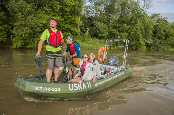
Scientists travelled the section from the Goczałkowice Reservoir to the Bay of Gdańsk by water to analyse the water in place and collect samples for laboratory tests. Some of the people were kayaking, and our research boat UŚka II also set out on a journey. The participants of the expedition had a rare opportunity to see Poland from the perspective of the Vistula River. They passed Wawel and the National Stadium, saw wild landscapes located mainly in the north of our country, stopped for a moment in Czerwińsk, where the Polish army, together with King Władysław Jagiełło, crossed the river in July 1410, using the so-called boat bridge.
– It is an entirely new experience for me. First, we were accompanied by the urbanised regions of the southern part of Poland, then the landscape changed unexpectedly and we only had a wide, vast, beautiful, wild river around us – recalls Andrzej Woźnica, PhD, DSc, Associate Professor, director of the ŚCW UŚ, leader of the team of scientists participating in the project.
Together with Dariusz Halabowski, PhD, from the University of Silesia he participated in the expedition from the source to the mouth of the river, steering the university research boat. Accompanied by Agnieszka Babczyńska, PhD, DSc, Associate Professor, the three of them sailed from Goczałkowice to Oświęcim. At this point A. Babczyńska was replaced by a team of hydrobiologists represented by Anna Cieplok, PhD, and Adrianna Koczorowska, MA, who reached Czerwińsk. From this place, up to Gdańsk, the research journey was continued by hydro-philologists, Aneta Spyra, PhD, DSc, Associate Professor, and Mariola Krodkiewska, PhD, DSc, Associate Professor. The expedition was also attended by: on the route from Krakow to Solec, photographer and helmsman Marek Grucka and chemists: PhD student Katarzyna Bednarczyk, together with Marcin Libera, PhD. Wojciech Szlęk, representing Górnośląskie Przedsiębiorstwo Wodociągów SA, who took care of the efficiency of the boat, joined in Połaniec. The team was supported by Bartosz Łozowski, PhD, who transported the equipment and helped the members of the team to reach particular places.
Hydrologists, Damian Absalon, PhD, DSc, Associate Professor and Magdalena Matysik, PhD, DSc, traversed the route by land and joined the boat crew in specific locations of the river to analyse the flow of water on subsequent sections of the Vistula riverbed. Scientists analysed 12 parameters of water directly during the kayak trip, such as: dyes indicating the presence of algae and cyanobacteria, conductivity, oxygen content in water, organic substances dissolved in water. They also took samples for laboratory analyses, on the basis of which laboratory analysis of waters, analysis of phytobenthic and planktonic organisms was carried out.
Andrzej Woźnica adds that one of the most interesting parameters studied is the amount of organic compounds dissolved in water.
– From the preliminary analyses, we managed to identify at least two places in the northern part of Poland, where we can talk about some anomalies. In the report, we will try to interpret the obtained results and indicate the source of these anomalies – comments the scientist.
Interesting information was also provided by the conductivity analysis mentioned earlier. The results of the research presented on the map of the Vistula route clearly show the influence of the mining industry on the salinity of its waters, while the characteristic influence of the industrial nature of Silesia and Zagłębie is weakening, starting from the place where the Dunajec flows into the Vistula, i.e. from the vicinity of Opatowiec.
– We collected samples for comprehensive analyses at 20 designated points along the entire length of the river. We sent them to an accredited water quality laboratory for analysis. It is worth noting that while flowing along the Vistula river, we examine the same water fed by successive tributaries to show how its state changes depending on the place. This is synchronous collecting of samples – explains a biologist from the University of Silesia.
How to organise it all?
The implementation of an unusual idea is a huge logistical challenge. Although each of the helmsman has the appropriate qualifications, it can be said that they learned how to navigate from scratch by taking part in the research. Different water levels and the shape of the bottom changing from hour to hour, strong current, a few tricky points, and above all, an incredibly long route covered at an average speed of 18 km / h – these is the everyday life of people involved in the project. – It happened that the navigation signs acted like sirens on Odysseus and led us to a catastrophe, to a sandbank. The first failure was a big challenge, we have dealt with the next ones much better – admits Andrzej Woźnica.
– Particularly difficult in terms of orientation turned out to be the section near Annolesie, with the current of the water so wide that we could… get lost. Unlikely? Yet possible. It also happened that for several dozen kilometres there were only us, two banks and it – a beautiful river. No bridges, ferries, ships … – adds the researcher.
There were also some challenges related to the method of collecting samples. It turned out not to be possible in every place, so scientists had to be inventive to ensure that the material for research was of appropriate quality. Such a problem was, for example, the extremely fast current, in which the equipment had to be loaded with additional ballast weighing 17 kg, so that water and bottom sediment samples could be taken at the indicated place.
– Thanks to this, we have gained very interesting experiences related not only to planning similar expeditions, but also to collecting samples for analysis depending on the conditions prevailing at the moment – emphasises the scientist.
An interesting idea was also to make an interactive map available on the foundation’s website. Thanks to this tool, people interested in the expedition could check where the team of researchers was at a given time.
The collected material is currently being analyzed. As many as five teams were involved in this task, in which both biologists, hydrobiologists, hydrolologists and chemists work. People working in water supply companies are already interested in the results of the research. Certainly, the analyses can be interesting material for the communes through which the Vistula flows, if only because of its tourist and recreational values. Perhaps the report will also indicate some solutions that will make the waters of the Vistula River cleaner and therefore safer for us. The research will also provide arguments for and against the practices of regulating riverbeds in our country. However, we still have to wait for the results of scientists’ work.
Direction: Odra River!
Scientists want to internationalise their research to ultimately build a water quality analysis network for various European rivers. A successful expedition allows you to think about continuing the project. They are already planning to take action on the Odra in cooperation with a group from the Czech Republic and Germany.
– The Odra River is a largely regulated river, but still remains a very interesting scientific object. Ultimately, we could compare our results for these two most important Polish rivers and draw additional conclusions – says Andrzej Woźnica.– I am pleased to be involved in the continuation of the research also due to the very good cooperation with the Why Not Foundation, which I would like to emphasise. We have met great people. I think that the key to success was precisely the team, thanks to which the whole expedition took place in a friendly atmosphere.
The article entitled “Blue Vistula, grey Vistula …” was published in the October issue of “Gazeta Uniwersytet UŚ” no. 11 (291)..
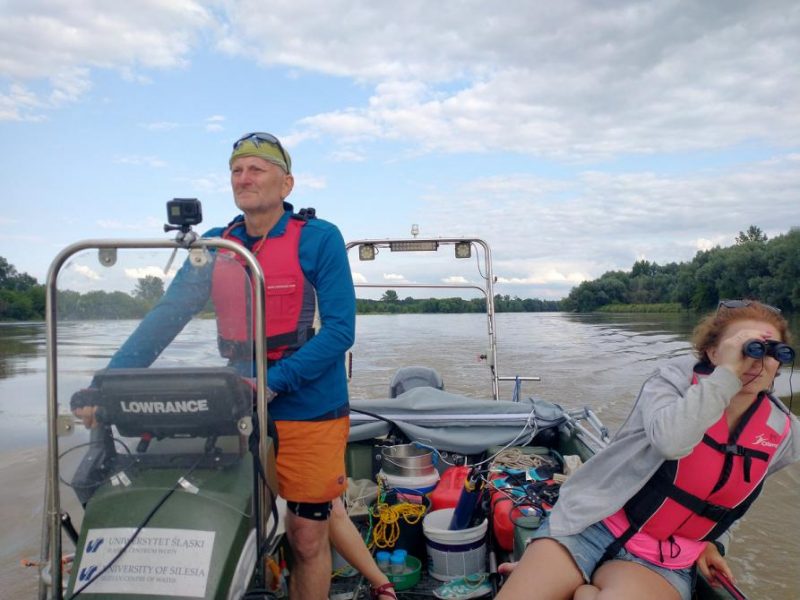
Looking for navigational signs on the Vistula. At the helm, Andrzej Woźnica, PhD, DSc, Associate Professor | photo by Dariusz Halabowski